Other Name(s)
St. Peters Canal National Historic Site of Canada
St. Peters Canal
Canal de St. Peters
Links and documents
Construction Date(s)
1854/01/01 to 1869/01/01
Listed on the Canadian Register:
2008/02/28
 Statement of Significance
Description of Historic Place
St. Peter’s Canal National Historic Site of Canada is a man-made water channel that connects the Bras d’Or Lakes with St. Peter’s Bay on the Atlantic Ocean in St. Peter’s, Nova Scotia together with its associated landscape.
Heritage Value
St. Peter’s Canal was designated a national historic site of Canada because it is part of Canada’s system of canals.
The heritage value of St. Peter’s Canal lies in the cultural landscape directly associated with the construction and operation of the canal including the land and water areas which were modified, blasted, graded or dredged during every construction phase and stage of canal use.
St. Peter’s Canal was originally built in several phases 1854-1869, and enlarged twice. It has been in continuous operation since its construction as a transportation facility for commercial and industrial goods during the 19th and early 20th centuries, and more recently for pleasure craft.
Source: Historic Sites and Monuments Board of Canada, Minutes, 1987.
Character-Defining Elements
Key elements that contribute to the heritage character of the site include:
- the inter-relationship of the canal waterway, works, buildings, and landscape features;
- the location of portions of the cultural landscape associated with the canal in all its periods of operation including the immediate approaches to the channel, the canal itself, its walls, the first lock chamber, and lock, and their relationship to one another;
- the presence, forms and materials of buildings and structures associated with canal operations on the canal site (in particular the lockmaster’s residence and the moveable swing bridge) in their evolved design and construction through the 19th and early 20th century;
- the route, fabric, composition and craftsmanship of the 800-metre canal passage cut through a granite hill;
- the location and presence of piles of spoil on the adjacent ocean and lake shores;
- the use as a transportation corridor;
- viewplanes of economically developed areas from the canal, particularly those containing evidence of activity fostered and supported by the presence of the canal as a transportation corridor to foster national and international trade and commerce in the 19th and early 20th century.
 Recognition
Jurisdiction
Federal
Recognition Authority
Government of Canada
Recognition Statute
Historic Sites and Monuments Act
Recognition Type
National Historic Site of Canada
Recognition Date
1929/05/17
Historical Information
Significant Date(s)
1854/01/01 to 1940/01/01
Theme - Category and Type
- Developing Economies
- Technology and Engineering
- Developing Economies
- Communications and Transportation
- Developing Economies
- Labour
Function - Category and Type
Current
- Transport-Water
- Canal or Canal Works
Historic
Architect / Designer
n/a
Builder
n/a
Additional Information
Location of Supporting Documentation
National Historic Sites Directorate, Documentation Centre, 5th Floor, Room 89, 25 Eddy Street, Gatineau, Quebec
Cross-Reference to Collection
Fed/Prov/Terr Identifier
314
Status
Published
Related Places
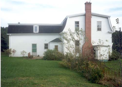
Lockmaster's House
The Lockmaster’s House is a tall, wood framed structure with a distinctive mansard roof and an asymmetrically positioned rear wing. One of the oldest buildings in the community of…